The Tourist Bureau has come up with a map with seven circuits covering the different areas of Corrèze. They range from 95 km to 130 km, each a perfect day trip. UNTIL you realize that they have not accounted for any stops along the way. At the rate we're going, it will take all of two months to do the circuits and we'll still have missed many wonderful places!
We left towards Égletons and stopped to enjoy many scenes along the way.
No clear cutting here, but I do hope it won`t erode the road edges that are already precarious.
Lake reflecting cotton ball clouds.
Mary hasn't lost her little lambs, but the lambs have lost their fleece!
So many places for sale, both in towns and in the countryside.
We stopped briefly in Moustier-Ventadour and looked into the church of St. Pierre. Karl is becoming fascinated with church bells. Sometimes there are 4, sometimes 2.
We had lunch in Égletons, at the Hotel Restaurant Sarl Borie.
I had the quiche Lorraine with the freshest salad ever. Just plain butter lettuce with a lemon vinaigrette.
Karl started with the plate of "charcuterie", or cold meats.
He followed that up with lasagna which he said was delicious. We shared a demi pichet (half pitcher) of rosé wine.
We ended on a sweet note: chocolate religieuse for me, and café religieuse for Karl. Those are cream puffs filled with chocolate or café pudding, and a caramel sauce holding it all together with a trim of piped whipped cream.
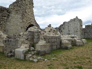
We then toured the "Forteresse de Ventadour" for a couple of hours. Only a few vestiges remain on the site of this 11th century feudal castle, which is still remarkably wild. It is on the route of the troubadours. A troubadour was a composer and performer of Old Occitan lyric poetry during the High Middle Ages (1100 - 1350). One of the most famous troubadours was Bernart de Ventadour.
This side door opened into the "souricière" which has nothing to do with mice. (Souris means mouse.) It's an enclosed room where the enemy that had managed to breach the first defence would be trapped, like in a "mouse trap".
Classed as a historic site in 1946, the site was already strongly damaged by demolition contractors of bygone years. In 1965, consolidation work and excavations were undertaken to try to reconstitute the former splendor of the fortress.
The perspective of this photo shows you how steep the land around the fortress is, and how difficult it was for an enemy to reach the fortress.
These strewn stones are actually the materials being used for reconstruction.
The original cistern, where they drew their water.

Note the rocky walls which are then covered with cut stone.
The remnants of the chapel. You can see where the footings were.
Can you see me on the right? It gives you an idea of how high the walls are.
Rounded walls were built way before the 11th century by talented masons. The Romans were masters at that.
Front door of the fortress which opened to a breathtaking view of the entire valley.
***


Marguerite! Finally catching up on your trip! WOWsers! The food! The sights! You lucky lady! ENJOY!!!
ReplyDeleteWe are definitely enjoying every moment!
DeleteWhat an interesting find! Definitely worth exploring!
ReplyDeleteThe photos don't really capture how expansive and breathtaking it was. We felt like birds.
Deletemarvelous & so interesting but the food looks so good I've put on 5 pounds since you left keep me posted I need a few more pounds
ReplyDeleteOh dear, you'll be weighing a LOT more in two months! There are so many restaurants out there just waiting for us to taste their fare.
Delete